Stikine Trip Report
We would like to first extend a huge thank you to the American Alpine Club's Mountaineering Fellowship Fund, American Alpine Club's Live Your Dreams Grant, British Mountaineering Council's Julie Tullis Memorial Award, NOLS Instructor Development Fund, NOLS Alaska Branch, and for everyone who skipped a beer to buy one of our stickers to help fund this expedition. Even though we did not achieve either of our initial objects, it felt powerful to be able to push ourselves with an inspiring group of local Alaskan women. Everyone in the expedition challenged themselves. At the same time the group had spent enough time in the mountains to have respect for serac walls, avalanches, and poor weather conditions. A huge part of mountaineering is learning humility. We left the Stikine Icefield a while ago, but we mentally go back to the base of that icefall often.

Group photo at the base of the icefall. Photo by Hannah Rosenkrans
Alaska Mountain Women was an all female 21.04 mile ski mountaineering climbing project with two first ascents objectives (UTM coordinates 0662272E 6327803N and 0659830E 6316386N) of unnamed, unclimbed peaks on the remote Stikine Icefield in Southeast Alaska. The route incorporated snow covered glacial travel, icefall navigation, and travel on steeper 30-50 degree slopes. The goal of the climb was to cultivate a strong community of local women dedicated to challenging and educating others and ourselves about alpine glacial mountaineering and remote mountains. We shared our story and planning process along the way in hopes to spark a desire for exploration amongst other outdoor enthusiasts.
To prepare for the expedition the team members met bi-weekly since October 2017. One meeting was dedicated to route planning, fundraising, outreach, logistics, and grant writing. The other meeting’s purpose was to review skills such as knot/rope handling, building anchors, belaying, fixed rope ascension, ski travel communication on a rope team, ascending a fixed rope, 2:1 and 3:1 crevasse rescue systems, self arresting, technical movement on snow and ice, snow step-kicking, rope snow travel management in crevasse terrain, route finding on glacier, snow protection, probing techniques, avalanche knowledge, crampon technique, transceiver use, off-trail navigation, and map reading. All expedition members were required to have a current Wilderness First Responder certification, have taken an avalanche I course, have at least one winter of backcountry skiing experience, and at least one summer season of snow covered glacial travel experience. The skills practice, mandatory prior experience, individual certifications, along with the group planning meetings tremendously contributed the expedition’s overall success. In the seven months leading up to the trip, the group learned how to work together for a common goal, practiced skills, read incident reports, and learned from each other’s diverse backgrounds and skill sets.
The expedition occurred between April 30th, 2018 to May 8th, 2018 with Mary Gianotti, Hannah Rosenkrans, Rebekah King, Beth Loudon, Katie McCaffrey, and Auri Clark. The group ferried to Petersburg from Juneau on the morning of April 30th. The original plan was to fly onto the Stikine Icefield that day if the weather permitted. Weather was not permitting until the afternoon of May 2nd. Poor weather conditions on the helicopter flights over caused the helicopter to land at an unplanned location on the East Fork of the Patterson Glacier, seven miles to the west of where we had originally planned to be dropped off on a medial moraine right above the exposed blue ice of a lower icefall (coordinates 56 57ˈ35. 98ˈN, 132 32ˈ36. 98ˈ W at 2380 feet of elevation). Limited visibility prevented the helicopter pilot from landing above the second snow covered icefall or from flying close enough to determine if there was a potential route through it. That night we camped at our drop off location.

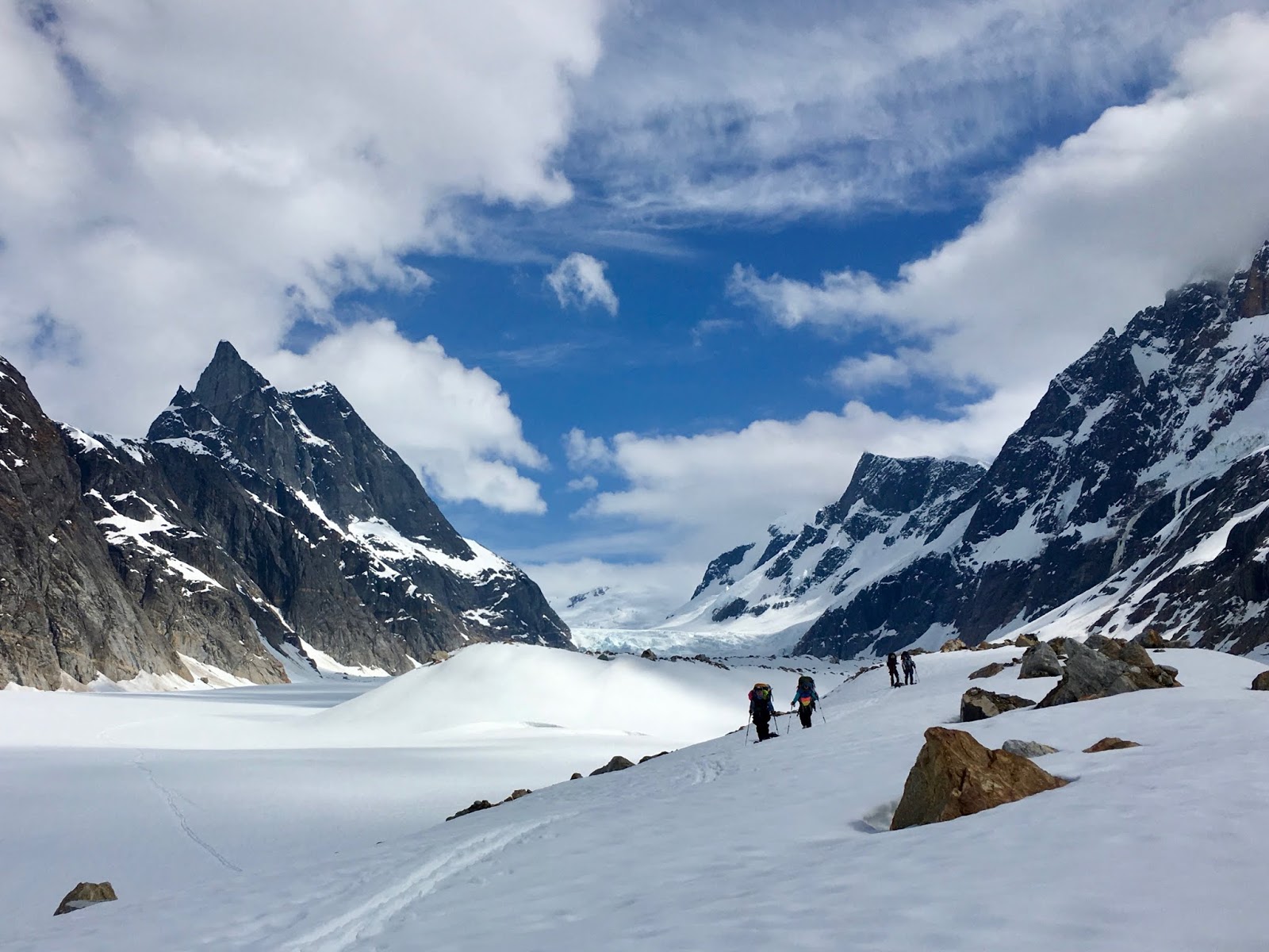
The next day the group skied roughly 2.5 miles up glacier to a camp in the middle of the snow covered glacier approximately a quarter mile from the base of the snow covered icefall at coordinates 56 57ˈ13. 35ˈN, 132 28ˈ59. 30ˈ W at 3230 feet elevation.

Photo of our second camp at the base of the snow covered icefall to our east. Photo taken on the northwest corner of our perimeter camp. Icefall visible in the background. Photo by Mary Gianotti.
The next three days was spent base camping at the second campsite and attempting to scout a route on the icefall. Each day two members of the expedition would stay in camp in case of emergency and a rope team of four members would search for a route. Both the members in camp and the members scouting the icefall had emergency communication devices- either a satellite phone or an InReach. Additionally, one member of the rope team had a beacon on. We did not have everyone on the rope team turn their beacon on because of the rope team. The first two days navigating the icefall were 30-40 F temperature days in rainy snowy white out conditions.

Diagram of three days of scouting a route through the icefall. Photo by Auri Clark.
Looking at the icefall from camp, there appeared to be two snow ramps on the south side of the icefall that looked like they could go. When closer to icefall, the group realized that the ramp farthest south was beneath loaded cornices, serval serac walls with recent calving activity, and was on a slope of over 30 degrees. Because of these high risk factors, the team decided to not attempt the farthest south snow ramp and decided to focus on a route through the other southern snow ramp. Each day the group would get closer up the icefall. First day the team traveled ~75% up the icefall, the second day ~80% up the icefall, and the final day the group traveled ~90% up the icefall. However, each scout was ended because of the inability to get through free-standing seracs and deep crevasses.
On the final day of icefall navigation, the weather increased drastically overnight to over 60 F with blue skies. This quick change in temperature after several days of wet heavy snow loading caused the snowpack to become unstable. A loaded cornice on the ridge to our south broke. The avalanche cascaded down to several free standing serac walls. The snow caused the serac walls to collapse and begin moving towards the rope team. The avalanche stopped rough 50 meters away from the rope team. The rope team was outside of the terrain trap and too far north to be affected by that particular avalanche.

Diagram of wet slab avalanche that occurred on the north facing slope directly south of the snow covered icefall on the east fork of the Patterson Glacier. Photo by Auri Clark.
However, after the close encounter with the avalanche, the group decided to be back to camp. The camp was situated over 100 meters west of the icefall in the center of the snow covered glacier on a less than five degree slope. The campsite was in a safe zone from avalanches. After the day of bluebird weather the team accessed the weather forecast. The weather was forecasted to have another two days of flyable helicopter weather until another storm system moved in. The storm system moving in was predicted to be in the area for over a week. Because of uncertainty of how long the storm system was going to last, the expedition decided to have the helicopter pilot fly us out while we still had the weather window. The following morning the crew skied back to the original helicopter drop off spot. The next afternoon the pilot came to pick everyone up.
Ski back to the original helicopter drop off point. Photo by Mary Gianotti.
Because of the high avalanche risk, poor weather conditions, and impassable icefall we unable to reach our original starting point of the traverse or find another way to reach the desired peaks. Even though our initial objects were not achieved, it felt amazing to be able to challenge oneself with a group of people who have a lifelong love for glaciated peaks in Alaska. Everyone in the expedition pushed themselves and at the same time respected the power of big mountains. When mountains speak it is important to truly listen. One of the biggest lessons one can learn from the mountains is how to be humbled by them.


Comments
Post a Comment